 |
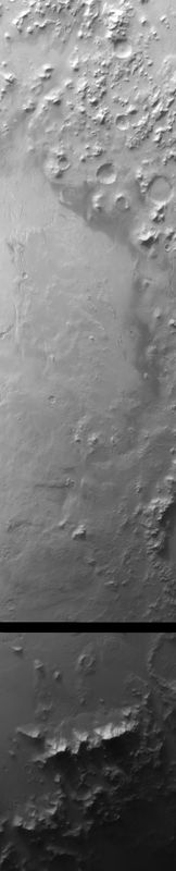
MOC wide-angle image E20-01137
Red WA Argyre Planitia survey
Ancillary data for MOC wide-angle image E20-01137
Acquisition parameters
     Image ID (picno): E20-01137
     Image start time: 2002-09-21T03:57:51.80 SCET
         Image  width:    864      pixels
         Image height:   4256      pixels
Line integration time:     80.4800 millisec
   Pixel aspect ratio:      1.01
   Crosstrack summing:      1
    Downtrack summing:      1
     Compression type: MOC-NONE
            Gain mode:     2A (hexadecimal)
          Offset mode:      5 (decimal)
|
Derived values
Longitude of image center: 36.92°W Latitude of image center: 49.47°S Scaled pixel width: 244.06 meters Scaled image width: 219.13 km Scaled image height: 1051.63 km Solar longitude (Ls): 71.09° Local True Solar Time: 14.45 decimal hours Emission angle: 18.29° Incidence angle: 80.49° Phase angle: 63.24° North azimuth: 94.85° Sun azimuth: 60.38° Spacecraft altitude: 372.24 km Slant distance: 389.95 km |
Policy regarding use of processed images
Release date: 30 September 2003